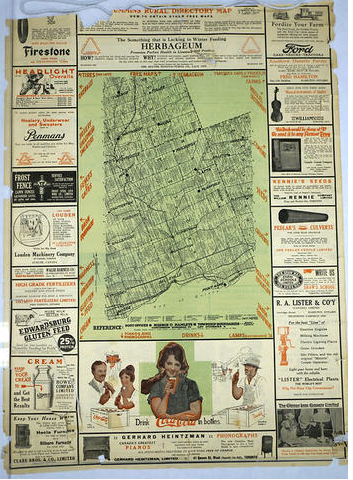
Date of the items: 2023
Physical description: one map copied in six sheets
Title: Cummins Rural Directory 1924
Creator: Cummins Map Company, Toronto, Ontario
Donor: Elwood Jones, January 2024
Repository: Trent Valley Archives
Reference number: TVA Fonds 1104
Scope and contents: Cummins Rural Directory Map 1924. The map shows property owners and hamlets and sidings across Peterborough county and neighbouring parts of Victoria, Durham and Northumberland. It matches in style the historical atlases of the 1870s and 1880s, and the Illustrated Historical Atlas of the city and county of Peterborough.
Access Conditions: No Restrictions
Finding aid: Contained here
Accruals: no further accruals are expected
Custodial history: The map was copied in six parts by the Library and Archives Canada, December 2023. The map was created as a pdf and a printed copy of each section was made. This was used to create a rough guide to the locations.
The map that was in the Martha Kidd fonds was a Photostat of a map that she had sent to the Public Archives of Canada. This map was then copied as a replacement.
Biographical sketch/ Administrative history: The O.F. Cummins Map Company was established around 1917 in Regina, Saskatchewan. The company’s office was located at 12-2350 12th Avenue (Co-operative Elevator Building). The president of the company, Oliver Francis Coumans, was an engineer and land surveyor. He changed his surname to Cummins around 1917, after which the company was known as the Cummins Map Company. Melville S. Arneil, a draftsman, was vice-president and manager. In 1918, Cummins moved to Winnipeg, Manitoba, where he initially operated a branch office of the company out of his home. The Winnipeg office was later located at 904-457 Main Street and 404-160 Princess Street. Arneil maintained the Regina office until around 1920, when he closed that office and moved to Winnipeg. In 1923, Cummins moved to Toronto, Ontario, followed by Arneil in 1924. The company office was located at 70 Lombard Street. Cummins was involved in other work after 1927 but Arneil continued to manage the company until it ceased to operate in the early 1940s.
The main product of the Cummins Map Company was a series of landowner maps, known as the Cummins Rural Directory Maps, for Alberta, Saskatchewan, Manitoba, Ontario and Prince Edward Island. The rural directory maps contained the names and locations of post offices, the location of local rail lines and the names of the owners of each parcel of land within the area covered. The maps were issued as collections of single map sheets instead of being bound in book form as many of the atlases were at the time. The maps were often used by local merchants and travelling salesmen to find customers as well as to assist travellers to find their way across unfamiliar and often unmarked land. The Saskatchewan map series were produced in 1917/1918 (covering most of the settled areas of the province); 1920; 1922; 1926 (covering eastern Saskatchewan) and 1930 (covering north-central Saskatchewan). An uniform sheet numbering system was used and maintained in all series.
Some of the other products produced by the Cummins Map Company included an atlas of Prince Edward Island and Cummins Crop Yield Maps, which indicated the crop yields of the prairie provinces using a “good, fair and poor” rating system. The company also advertised their mounting and drafting services. [Source: Saskatchewan Archives]
Related fonds at TVA:
Victoria County map, 1877
Map collections
Atlases
Access:
List of sections:
- Smith to Dummer: Points noted include Young’s Point, Kawartha Park, Selwyn, Botulf, Nassau Mills, Douro, Guerin, Indian River, Cottesloe, Dummer, McCracken’s Landing; Hall Glen, Douro, Warsaw, Galesburg, Lakefield.
- Dummer con 5 to county boundary. Points noted Norwood, Trent River, Havelock, Blairton, Preneveau, Blairton, Chase, Ryestone,Wariston, Cordova Mines, Round Lake, Clarina.
- Omemee to Douro. Points include Omemee, Downeyville, Ennismore, Emily,Bridgenorth, Peterborough, Jones, Mount Pleasant, Kingsware.
- Warkworth to Havelock. Points include Warkworth, Norham, Meyersburg, Campbellford, Hoard, Menie, Burnbrae, Ryestone, Trent River.
- Peterborough to Cavan. Points include Peterborough, Cavan, Morrow, Millbrook, Frazerville, Carmel, Baillieboro, South Monaghan, Lorenz, Bensfort, Smithbank, Stewart Hall, Claraday, McMartinville, Botulf.
- 6 Nassau Mills to Rice Lake and Asphodel. Points include Nassau Mills, Graystock, Drummond, Keene, Lang, Hastings, Dartford, Brickley, Norwood, Cottesloe, Guerin, Douro.

